On either side the river lie
Long fields of barley and of rye,
That clothe the wold and meet the sky;
And through the field the road runs by
To many-towered CamelotAlfred, Lord Tennyson, The Lady of Shalott
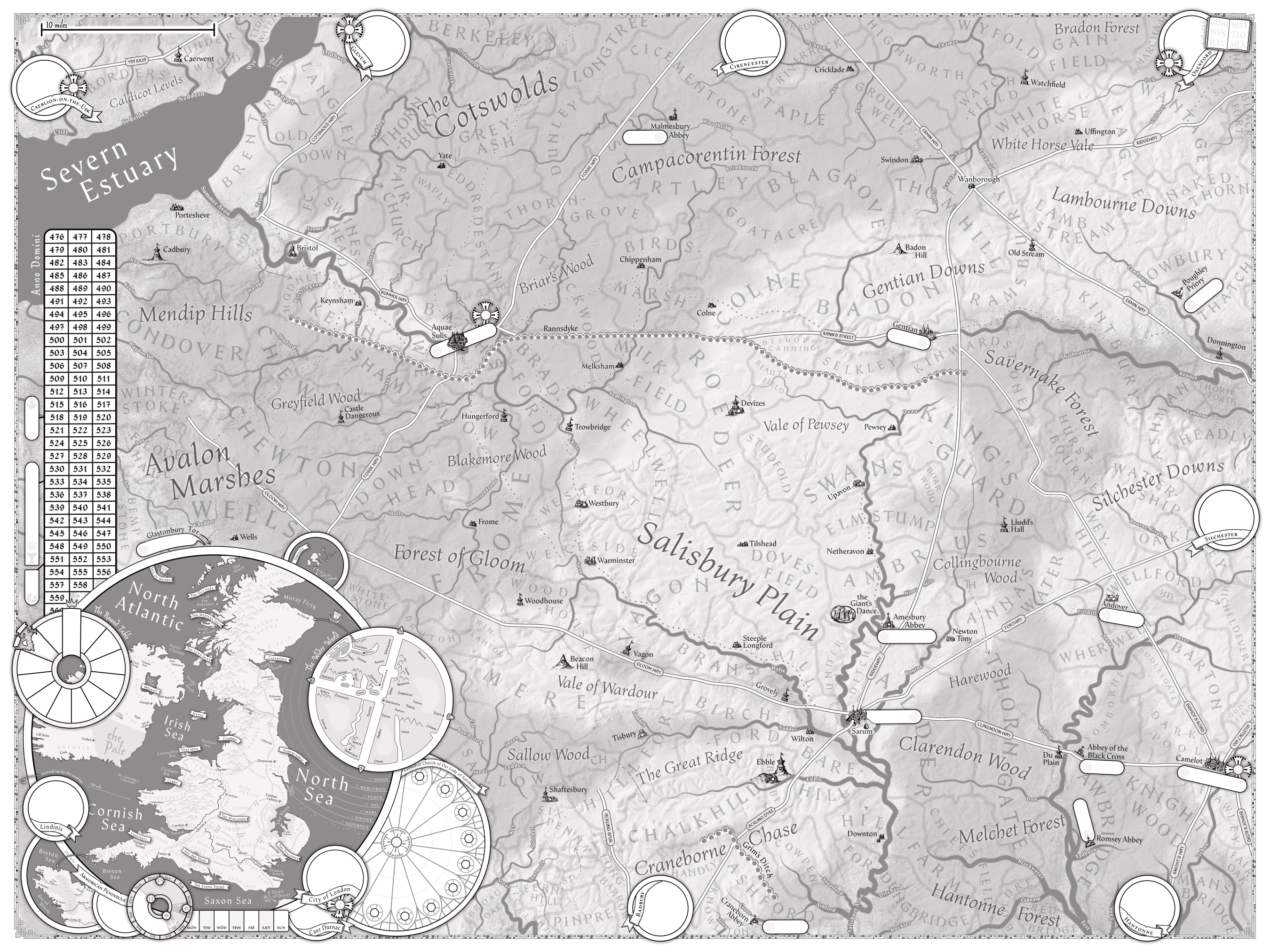
The 3x4 foot map of the County of Salisbury and its environs is a major aid for The Death of Arthur.
WIP
There are, of course, many locations on the map.
Nearby Regions
| Place | (one) Journey from Sarum |
|---|---|
| Caerlion-on-the-Usk | North-West across the Gloom Way to its intersection with the Fosse Way, to its intersection at Aquae Sulis. Take then the Summer Way and the Summer Avon west into the Severn Estuary, and so west to the Usk (off-map). |
| Glevum | North-West across the Gloom Way to its intersection with the Fosse Way, north up to Aquae Sulis to meet the Summer Way west to the Cotswold Way north (off-map) to the town. |
| Cirencester | North-North-West - taking the Ridgeway up to the Wanborough with its crossing with the Ermin Way, continuing north (off-map) direct to the town. |
| Oxenford | North-East, taking the Ridgeway (off-map) towards that town. |
| Silchester | East-North-East along the Portway direct (off-map) to the town. |
| Hantonne | East-South-East, taking the eastern Clarendon Way to Camelot, then south via the Knight’s Way direct (off-map) to the town. |
| Badbury | South, along the Ackling Dyke. |
| Lindinis | South-West, starting west on the Gloom Way until it reaches the Fosse Way, then turn south. The town and its environs would actually be on-map, but in the area covered by the inset. |
| Caer Durnac | South-West, via either Lindinis or Badbury ways, then along paths not shown. |
Areas
| Place | Type | (one) Journey from Sarum |
|---|---|---|
| Caldicot Levels | ||
| The Cotswolds | ||
| Campacorentin Forest | ||
| White Horse Vale | ||
| Bradon Forest | ||
| Lambourne Downs | ||
| Gentian Downs | ||
| Savernake Forest | ||
| Silchester Downs | ||
| Clarendon Wood | ||
| Harewood | ||
| Collingbourne Wood | ||
| Melchet Forest | ||
| Hantonne Forest | ||
| Craneborne Chase | ||
| The Great Ridge | ||
| Sallow Wood | ||
| Vale of Wardour | ||
| Salisbury Plain | ||
| Vale of Pewsey | ||
| Briar’s Wood | ||
| Blakemore Wood | ||
| Forest of Gloom | ||
| Avalon Marshes | ||
| Mendip Hills |
Major Roads
| Place | (one) Journey from Sarum |
|---|---|
| Via Julia | |
| Cotswold Way | |
| Summer Way | |
| Gloom Way | |
| Fosse Way | |
| Ermin Way | |
| Ridgeway | |
| Rann’s Street | |
| Portway | |
| Ackling Dyke | |
| Acklying Spur | |
| Clarendon Way | |
| Bishop’s Road | |
| Knight’s Way | |
| Via Calleva |
Rivers
| Place | Type | (one) Journey from Sarum |
|---|---|---|
| Severn Estuary | ||
| Usk | ||
| Clift | ||
| St Bride’s | ||
| Neddern | ||
| Mounton | ||
| Wye | ||
| Axe | ||
| Lox | ||
| Cheddar | ||
| Blagdon Yeo | ||
| Kenn | ||
| Yeo | ||
| Summer Avon | ||
| Malago | ||
| Trym | ||
| Salt | ||
| Stuppil | ||
| Oldbury | ||
| Ozleworth Brook | ||
| Tortworth | ||
| Laddon | ||
| Frome | ||
| Brislington | ||
| Siston | ||
| Boyd | ||
| Chew | ||
| Winford | ||
| Newton | ||
| Cam | ||
| Wellow | ||
| Somerset Frome | ||
| Mells | ||
| Biss | ||
| Semington | ||
| Woodbridge | ||
| Brinkworth | ||
| Lam | ||
| By | ||
| Thames | ||
| Childrey | ||
| Ock | ||
| Churn | ||
| Key | ||
| Ray | ||
| Cole | ||
| Liden | ||
| Lenta | ||
| Tuckmill | ||
| Kennet | ||
| Lambourne | ||
| Shalbourne | ||
| Enbourne | ||
| Itchen | ||
| Lane | ||
| Test | ||
| Cadnam | ||
| Blackwater | ||
| Tadburn | ||
| Dun | ||
| Wallop | ||
| Anton | ||
| Pillhill | ||
| Dever | ||
| Bourne Rivulet | ||
| Stour | ||
| Fontmell | ||
| Stirchel | ||
| Key (Dorset) | ||
| Stour | ||
| Lodden | ||
| Sheen | ||
| Cal | ||
| Bow Brook | ||
| Salisbury Avon | ||
| Huckles | ||
| Ashford | ||
| Sweatford | ||
| Crane | ||
| Ditchend | ||
| Ebble | ||
| Nadder | ||
| Fonthill | ||
| Wylye | ||
| Swan | ||
| Bourne | ||
| Nine Mile | ||
| Dean |